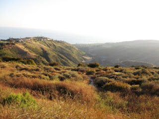
Aliso and Wood Canyon Wilderness Park
I have compiled a list of the best information available for the trails that I took on my most recent hike at Aliso and Wood Canyon Park. I started at Top of the World and hiked along west ridge trail to rock it trail to coyote run trail to nature loop to wood canyon trail to dripping cave to Mathis trail and return to top of the world on west ridge trail. This was a 7-7.5 mile loop. Perhaps the best feature this park has to offer is the ability to customize your hike. There are so many connecting trails that you make a loop any distance you want with a minimum of ground covered twice. The cons of this park are rattlesnakes and heavy mountain bike use. Dogs are only allowed on some parts of the hike. West ridge trail allows dogs on a leash. Beautiful scenery abounds; rolling hills, ocean views, interesting geological formations, flora, and fauna included. This is the closest to nature I have found in over populated Southern California. Check out the links at the bottom for detailed information and maps. All of the trails that I went on are moderate to difficult. Happy hiking!
Wood Canyon Trail: Wood Canyon Trail serves as the backbone to the 30-mile trail
system, providing access points and opportunities for loop trail excursions. The
varied vegetation along its length on the canyon floor, easy access to multiple
geological and biological interpretive sites, and fairly level grade allow for enjoyment
by a diverse group of recreationists. The Cave Rock and Dripping Cave Trails stem
from the trail in lower Wood Canyon with the historic Old Corral site past the
connection with Mathis Canyon Trail.
Dripping Cave Trail: A distance from the Wood Canyon Trail, Dripping Cave is a
popular natural interest point in the park. From the Dripping Cave, the trail leads
northwest, crossing the western ridge of Wood Canyon before dropping down to the
grassland at the floor of Mathis Canyon. Dripping Cave Trail connects with Mathis
Canyon Trail at its base.
Mathis Canyon Trail: At its start at Wood Canyon Trail, Mathis Canyon Trail begins
a gentle grade into Mathis Canyon through grassland with scattered elderberry
shrubs, sycamores and oak trees. At its junction with Oak Grove Trail the trail begins
a challenging ascent up Mathis Canyon. Ascending the trail offers panoramic views
of Wood Canyon, Moulton Peak, and the Rock-it Trail snaking down the ridge to the
north. Mathis Canyon Trail terminates at West Ridge Trail at an elevation of
approximately 700 feet.
Coyote Run Trail: Coyote Run Trail parallels Wood Creek on the west side and
connects the Wood Creek hiking trail and the popular Wood Canyon multi-use trail.
This trail provides a more scenic and varied alternative to the Wood Canyon Trail
because it skirts the lower portion of Wood Canyon’s west ridge rather than following
the canyon floor. At its northern end, just past the Old Sycamore Grove, the trail
crosses Wood Creek and connects with Wood Canyon Trail.
Rock-It Trail: The Rock-It Trail is a highly technical trail that is popular with mountain
cyclists. Named for its passage over sandstone rock outcroppings that begin about a
third of the way down, the trail originates from the top of Wood Canyon at the West
Ridge Trail. A popular loop opportunity commonly utilized by cyclists entering at the
main entrance includes a ride north up the Wood Canyon and Cholla Trails, a short
ride along the West Ridge Trail, and the steep downhill thrill provided by Rock-It.
Rock-It allows for access from the City of Laguna Beach via the Alta Laguna
Community Park and the Top of the World trailhead from West Ridge Trail. Rock-It
joins with Coyote Run Trail near the base of Wood Canyon.
West Ridge Trail: The West Ridge Trail is a graded fire road that provides access
from the Alta Laguna Community Park (City of Laguna Beach) and the Top of the
World area. Beginning at an elevation of approximately 1000 feet, the trail traverses
the ridge between Wood Canyon and Laguna Canyon. The trail continues north and
connects first with Mathis Canyon Trail, then Rock-it Trail at the water tank on El
Toro Ridge, followed by Stairstep Trail, and finally Lynx and Cholla Trails. Numerous unauthorized trails drop down to Laguna Canyon Road from the West Ridge Trail.
West Ridge Trail terminates at the Cholla Trail in upper Wood Canyon.
Nature Loop Trail: The Nature Loop Trail connects Wood Canyon and Coyote Run
Trail to provide a 0.5 mile “hikers only” loop around the west ridge of Wood Canyon
and the east ridge of Mathis Canyon. At its juncture with Coyote Run Trail, the
habitat transitions from coastal sage scrub to lush oak woodland and riparian
vegetation. Coyote Run Trail parallels Wood Creek and returns the hiker back to the
beginning of the Nature Loop just off of Wood Canyon Trail.
Destinations:
Dripping Cave. Dripping Cave is a popular natural interest point in the park. The sandstone
overhang tucked into the narrow canyon was once used by 19th Century stagecoach and
livestock thieves as a hide-out. Visitors can climb into the 15 x 40 foot cave for a closer
inspection, viewing the holes in the wall that were once fitted with pegs to hold supplies or
the blackened ceiling that is mistakenly thought to have been created by campfires.
Moisture dripping from the ledges sustains the ferns and other plants that frame the opening
of the cave.
Top of the World (TOW). The TOW vista point, at an elevation of approximately 1,050 feet,
places the park within a regional context with its breathtaking views of the Pacific Ocean and
Catalina Island, AWCWP sprawling to the east, and the San Gabriel and San Bernardino
Mountains beyond. TOW is accessed by the West Ridge Trail at Alta Laguna Park.
Thank you,
Chris Clark


No comments:
Post a Comment